Siida
The lapinkylä and the siida
Lapinkylä is the old administrative name for a village. In Sámi the same community is called a siida. Kittilä is one of those villages, not the whole system.
The word
North Sámi siida means a Lapp village or a reindeer village. The word is in every Sámi language. In the western Sámi languages it later meant a reindeer-herding community and its pastures. In the eastern languages it meant the village community and the winter village. (Encyclopaedia, Siida)
Finnish lapinkylä and Sámi siida usually mean the same thing. In the east, siida could mean in particular a community that practised its livelihoods in common. (Encyclopaedia, Lapp villages and tax lands)
Old documents say Lapp, because that is the word in the records of the time. On this site the people are called Sámi. Lapinkylä stays as the old name of the village.
Six regions, thirteen villages
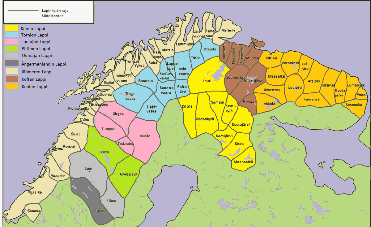
Historical Lapland was divided into six areas: Ångermanland, Umeå, Piteå, Luleå, Torne, and Kemi. Those were divided into villages, and the villages into family tax lands. (Encyclopaedia, Lapp villages and tax lands)
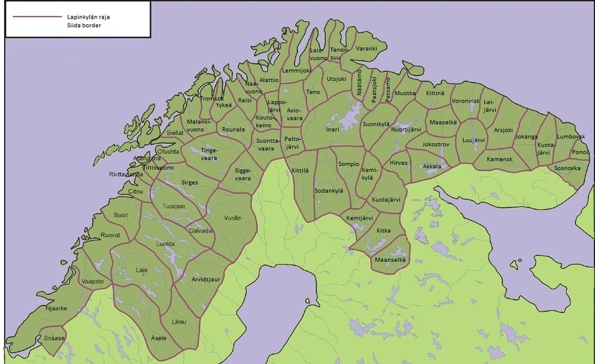
Thirteen villages lay wholly or partly in present-day Finland. In Torne Lapp: Rounala, Suonttavaara, Peltojärvi, Teno, and Utsjoki. In Kemi Lapp: Maanselkä, Kitka, Kuolajärvi, Keminkylä, Sompio, Sodankylä, Kittilä, and Inari. (Encyclopaedia, Lapp villages and tax lands)
Researchers have taken this division into villages and tax lands as originally the Sámi society’s own way of using the land. The states later used the same division for courts and for taxation. (Encyclopaedia, Lapp villages and tax lands)
The year and the tax land
Court books from about the middle of the 1600s say that in the Kemi Lapp villages, Forest Sámi hunted wild reindeer and beaver and fished, on a yearly round. They also owned some reindeer. Wild-reindeer hunting was done in common on the village’s land. On a tax land, the holder generally had the exclusive right to their own livelihoods. (Encyclopaedia, Lapp villages and tax lands)
The villages had fixed boundaries against each other. A boundary was a feature of the land, or a marker that had been made. If two villages disputed a hunting ground, a lake, or a fishing place and could not agree, the case went to court. (Encyclopaedia, Lapp villages and tax lands)
A tax land was a family’s area inside the village. Earlier it was called an inherited land. Until 1695 the tax land was the unit that paid. After the reform, the liability sat with the people living in the village. (Encyclopaedia, Lapp villages and tax lands)
The Kemi Lappmark villages on Tresk’s map in 1642Who taxed them
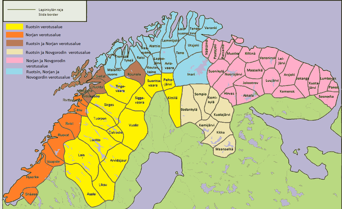
By the Middle Ages at the latest, the same villages were taxed by Sweden, Russia, and Norway. The king of Norway is known to have taxed the fishing Sámi of the Arctic coast already in the 1100s. In the 1200s Sweden gave the right to tax, and to trade, to the Birkarls. (Encyclopaedia, Taxation)
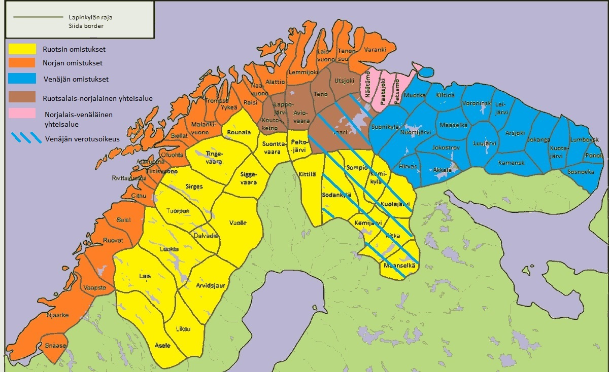
On the Swedish tax area, Sompio, Kuolajärvi, Kitka, Maanselkä, Keminkylä, and Sodankylä also paid Russia. Inari, Kautokeino, Aviovaara, Lappajärvi, Teno, and Utsjoki paid all three states. (Encyclopaedia, Taxation)
Joint Swedish and Norwegian taxation ended with the Peace of Strömstad in 1751. Russian tax in the more westerly Torne Lapp villages had already stopped at the end of the 1500s. In Kemi Lapp, tax to Russia was paid until 1814. (Encyclopaedia, Taxation)
Sources
- Encyclopaedia of Saami Culture. Siida (in Finnish).On the word siida. The article is not copied. The sentence is our summary.
- Encyclopaedia of Saami Culture. Lapp villages and tax lands (in Finnish).The six Lapp regions, the thirteen villages, the tax land, and the 1695 reform. The article is not copied.
- Encyclopaedia of Saami Culture. Taxation of the Lapp villages (in Finnish).Who taxed the villages, and when the joint taxation ended. The article is not copied.